Browse / Brazil / São Paulo / Indaiatuba
Indaiatuba
São Paulocity
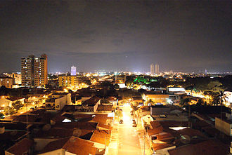
Featured view
Indaiatuba
Total population
255,748
Coordinates-23.09°, -47.22°
Demographic figures from IBGE. Overview below cites Wikipedia and may reference a different year.
Loading additional data from public sources…0 / 11
CensusWikipediaWeatherPlacesPeopleEnvironmentHealth & SchoolsRelatedGeography & CultureLive MonitoringEvents & Gallery
0% completeCity facts
Overview
Indaiatuba is a municipality in the state of São Paulo, Brazil. It is part of the Metropolitan Region of Campinas. The population is 255,748 in an area of 311.5 km2 (120.3 sq mi). The elevation is 624 m (2,047 ft). The city's name derives from the Tupi language, which roughly translates to "gathering of palm trees". It is an important city in one of Brazil's main industrial regions.
History & geography
Geography
Latitude
-23.0908
Longitude
-47.2181
Water area
—
Coordinates & boundaries from the US Census TIGER/Line shapefiles.
Climate
Air quality
Walkability
Amenities nearby
Wildlife & biodiversity
Earthquake history
Photos
Sights & places nearby
Notable people from here
Geography & sun
Nearby airports
Public attention
Books about this place
Recent natural events nearby
Ground air-quality sensors
Recently spotted species
Events
Gallery
Official Identifiers
IBGE — Brazilian Institute of Geography and Statistics
- IBGE code
- 3520509
- UF
- SP
- Mesorregião
- Campinas
- Microrregião
- Campinas
servicodados.ibge.gov.br
Sources
- • Wikipedia
- • Wikidata SPARQL (CC0) — population, area, elevation, inception, head of government, Commons image
- • IBGE — Brazilian national statistics, via servicodados.ibge.gov.br (official municipal code, UF, mesorregião, microrregião, region)
- • IBGE — Brazilian Institute of Geography and Statistics — servicodados.ibge.gov.br