Browse / Canada / Alberta / Dunmore
Dunmore
Albertahamlet
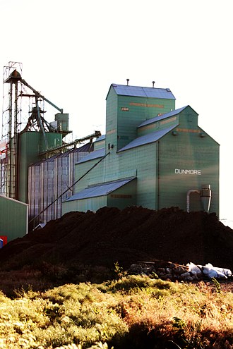
Dunmore
Total population
1,088
Demographic figures from Statistics Canada. Overview below cites Wikipedia and may reference a different year.
City facts
Overview
Dunmore is a hamlet in Alberta, Canada, within Cypress County, 2.6 kilometres (1.6 mi) southeast of Medicine Hat's city limits on Highway 1 and the Canadian Pacific Railway mainline. A portion of the hamlet is recognized as a designated place by Statistics Canada.
Read more on WikipediaHistory & geography
Geography
Coordinates & boundaries from the US Census TIGER/Line shapefiles.
Climate
Air quality
Walkability
Amenities nearby
Wildlife & biodiversity
Earthquake history
Photos
Sights & places nearby
Notable people from here
Nearby places in Alberta
Geography & sun
Elevation, sunrise/sunset and daylight from Open-Meteo. Solar climatology from NASA POWER.
Nearby airports
Public attention
Pageview totals from the Wikimedia Pageviews API.
Books about Dunmore
Search results from Open Library.
Recent natural events nearby
- Wildfire Middle Coulee, Chouteau, MontanaWildfires · 2026-08-02 · 156 mi
- Wildfire Camp Creek, Powell, MontanaWildfires · 2026-08-21 · 210 mi
- Wildfire Skillet, Lincoln, MontanaWildfires · 2026-07-29 · 219 mi
- Wildfire Ant Park, Meagher, MontanaWildfires · 2026-07-31 · 223 mi
- Wildfire Deer Creek, Lincoln, MontanaWildfires · 2026-08-20 · 239 mi
Wildfires, storms and other events from NASA EONET (last 12 months, within 250 mi).
Ground air-quality sensors
Recently spotted species
Events
Gallery
Sources
- • Wikipedia
- • Open-Meteo / sunrise-sunset.org
- • Wikipedia Pageviews API
- • Open Library
- • NASA EONET