Browse / Germany / Brandenburg / Rangsdorf
Rangsdorf
Brandenburgvillage
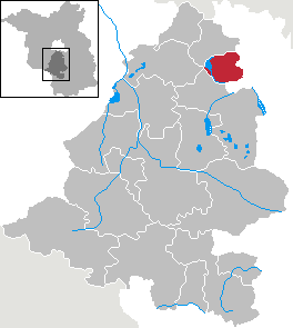
Featured view
Rangsdorf
Total population
10,609
Coordinates52.29°, 13.42°
Demographic figures from Destatis. Overview below cites Wikipedia and may reference a different year.
Loading additional data from public sources…0 / 11
CensusWikipediaWeatherPlacesPeopleEnvironmentHealth & SchoolsRelatedGeography & CultureLive MonitoringEvents & Gallery
0% completeCity facts
Overview
Rangsdorf is a municipality in the district of Teltow-Fläming in Brandenburg in Germany. It has an airfield [up to 1940 a genuine commercial airport] from where on 20 July 1944 Claus Schenk Graf von Stauffenberg took off on his fateful attempt to assassinate German leader Adolf Hitler at his military headquarters in East Prussia, the Wolfsschanze.
History & geography
Geography
Latitude
52.2914
Longitude
13.4189
Water area
—
Coordinates & boundaries from the US Census TIGER/Line shapefiles.
Climate
Air quality
Walkability
Amenities nearby
Wildlife & biodiversity
Earthquake history
Photos
Sights & places nearby
Notable people from here
Geography & sun
Nearby airports
Public attention
Books about this place
Recent natural events nearby
Ground air-quality sensors
Recently spotted species
Events
Gallery
Official Identifiers
Destatis — German Federal Statistical Office
- AGS
- 12072340
- Population (Wikidata)
- 11,846
- Wikidata
- Q625747
Amtlicher Gemeindeschlüssel (AGS) via Wikidata P439
Sources
- • Wikipedia
- • Wikidata SPARQL (CC0) — population, area, elevation, inception, head of government, Commons image
- • Destatis — German Federal Statistical Office — Amtlicher Gemeindeschlüssel (AGS) via Wikidata P439