Browse / Spain / Valencian Community / Benicarló
Benicarló
Valencian Communitytown
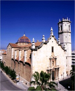
Benicarló
Total population
26,141
Founded
1236
Demographic figures from INE (Spain). Overview below cites Wikipedia and may reference a different year.
City facts
Sister cities
Facts from Wikidata (CC0).
Overview
Benicarló is a town and municipality in Spain, in the Valencian Community, in the Baix Maestrat region, of which it is the second largest by population. It borders Vinaròs, Càlig and Peniscola, as well as the Mediterranean Sea.
Read more on WikipediaHistory & geography
History
There are several places that either were inhabited or had a relationship with the Iberian population. The most important set is the Village of the Puig de la Nau, located at the foot of the hill of the same name. It is a site that has six phases of occupation, between 700 and 400 BC, of which part of the urban structure is preserved. The excavations found the Kylix of Penthesilea, an Attic cup, or the tresoret, a group of ornamental utensils. Currently, the findings are divided between museums in Castellón de la Plana and the Mucbe, located in Benicarló. At the foot of Puig de la Nau was the necropolis of the settlement, where several funerary remains were found. In addition, in the sea and at the mouth of the Riu Sec, an enclave known as Les Pedres de la Barbada, there is a submarine site, corresponding to the ancient Iberian port. The Puig de la Nau village was abandoned due to the decline of trade with the Greeks and Punics. In the following century, a new village was established on the hill of La Tossa, today between the municipalities of Benicarló and Càlig, which was also later depopulated. Although in the past the toponym Hystria (country of vineyards, named in the Maritime Ora of Rufius Festus Avienius) was attributed to the Village of Benicarló, this hypothesis is rejected today, as is the existence of a continuum between the Iberian and Muslim populations of the Middle Ages: after the depopulation of La Tossa, the current municipal area would have been occupied by modest Hispano-Roman estates. The first reference to the present-day Benicarló appears with the Arab farmhouse of Beni-Gazló or Bani-Gazlun. The scarcity of remains and documentary sources only allow us to sketch this enclave. It would be a small urban area, surrounded by a palisade, with a…
Geography
Located on the shores of the Mediterranean Sea, the municipality is located on a plain with orographic features of little relief, such as the Puig de la Nau (166 m), on the northern boundary of the municipality, and the Tossa (168 m). The rivers of the municipality have a perpendicular course to the coast: the Aiguaoliva to the north, the Rambla de Cervera (Riú Sec), in the center, and the Alcalà (Barranquet) to the south. It has the beaches: Mar Xica, Morrongo, Gurugú and Caracola.
Excerpted from the corresponding Wikipedia article (CC BY-SA).
Geography
Coordinates & boundaries from the US Census TIGER/Line shapefiles.
Climate
Air quality
Walkability
Amenities nearby
Wildlife & biodiversity
Earthquake history
Photos
Sights & places nearby
Notable people from here
Nearby places in Valencian Community
- Càlig4.7 mi away · pop. 1,908
- Santa Magdalena de Pulpis7.6 mi away · pop. 749
- Sant Jordi7.9 mi away · pop. 597
- Cervera del Maestre8.1 mi away · pop. 524
- Traiguera10.2 mi away · pop. 1,276
- la Jana11.1 mi away · pop. 672
- Alcalà de Xivert13 mi away · pop. 3,814
- Sant Mateu13.2 mi away · pop. 1,970
- Canet lo Roig13.2 mi away · pop. 686
- Sant Rafel del Riu13.6 mi away · pop. 502
- Alcossebre14.3 mi away · pop. 1,386
- Xert15.5 mi away · pop. 651
Geography & sun
Nearby airports
Public attention
Books about this place
Recent natural events nearby
Ground air-quality sensors
Recently spotted species
Events
Notable, recurring, and historical events associated with Benicarló, sourced from Wikidata.
Source: Wikidata (CC0).
Gallery
Geotagged photos within ~6 miles of Benicarló, from Wikimedia Commons contributors.
 0 mi
0 mi 0 mi
0 mi 0 mi
0 mi_-_panoramio.jpg) 0 mi
0 mi 0 mi
0 mi 0 mi
0 mi 0 mi
0 mi 0 mi
0 mi 0 mi
0 mi 0 mi
0 mi 0 mi
0 mi 0.1 mi
 0.1 mi
 0.1 mi
 0.1 mi
 0.1 mi
 0.1 mi
 0.1 mi
 0.1 mi
 0.1 mi
 0.1 mi
 0.1 mi
 0.1 mi
 0.1 mi
Photos via Wikimedia Commons — see each image page for license & attribution.
Official Identifiers
INE — Spanish National Statistics
- INE code
- 12027
- Population (Wikidata)
- 30,296
- Wikidata
- Q817302
Municipality codes via Wikidata P772
Sources
- • Wikipedia
- • Wikimedia Commons
- • Wikidata
- • INE — Spanish national statistics, municipality code via Wikidata P772
- • INE — Spanish National Statistics — Municipality codes via Wikidata P772