The town where the border runs through living rooms
Baarle-Nassau and Baarle-Hertog
A tangle of Dutch and Belgian enclaves along the border creates a town where nationality can change from one side of a cafe table to the other, marked by crosses painted on the pavement.

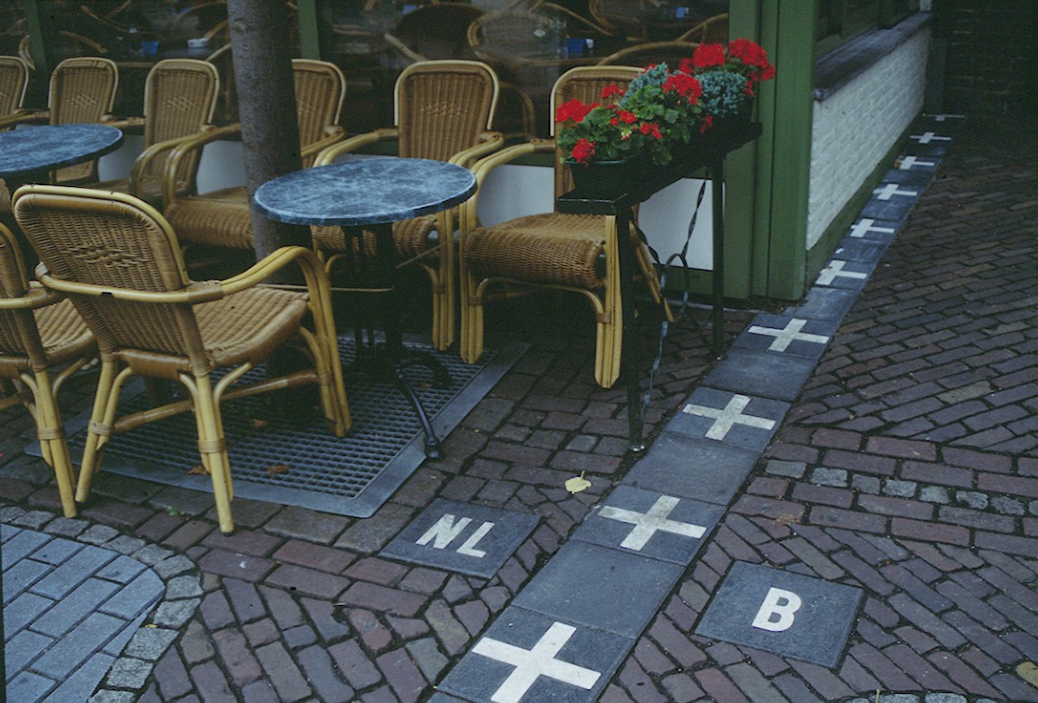
Along the border of Belgium and the Netherlands lies one of the most tangled international boundaries anywhere on Earth, a patchwork of more than twenty Belgian exclaves scattered inside the Dutch town of Baarle-Nassau, several of which themselves contain small Dutch counter-exclaves inside them. The result is Baarle-Hertog, the Belgian portion, and Baarle-Nassau, the Dutch portion, functioning almost as a single town on the ground even though its map looks like a jigsaw puzzle exploded across the countryside. The border is so intricate that it sometimes cuts directly through individual buildings, meaning a shop or house can have its front door in Belgium and its living room in the Netherlands, historically leading to quirks like different tax rules or closing times applying to different rooms of the same building. Locals mark the actual boundary line with small crosses and national letters, N for Nederland and B for Belgie, embedded directly into the pavement and sidewalks running through town. This administrative chaos dates back centuries to medieval land deals, treaties, and feudal boundary disputes between local lords, and rather than simplifying it, the modern governments have simply learned to live with, and even celebrate, the wonderfully confusing border town.
A medieval mess that stuck
The complicated border traces back to a series of medieval treaties and land transactions between the Duke of Brabant and the Lords of Breda, dating as far back as the 12th century, which parceled out plots of land in ways that did not correspond to any simple geographic logic. When Belgium and the Netherlands became separate modern nations in the 19th century, negotiators inherited this patchwork rather than untangling it, and subsequent border treaties in 1843 and 1995 largely preserved, and further clarified, the existing exclaves rather than eliminating them.
Enclaves within enclaves
Baarle-Hertog consists of 22 separate Belgian parcels of land scattered within Dutch territory, and remarkably, several of those Belgian exclaves contain still smaller Dutch enclaves entirely surrounded by Belgian land, a rare geographic phenomenon known as a second order enclave. This makes the Baarle area one of only a few places in the world with enclaves nested inside other enclaves.
Borders through buildings
Because the border follows historical property lines rather than modern city planning, it sometimes runs directly through individual buildings. The most famous example involves a house where the front door's location once determined which country's laws applied, leading to differences in matters like retail closing hours or tax registration depending on which side of a wall a business counted its address. Homeowners in such houses have historically had the choice of which country to register their official residence under.
Living with the border today
Rather than resolving the tangle, the town embraces it as a point of pride and tourist curiosity. Small metal crosses and letters, marked N or B, are set into the pavement and roads throughout town to show pedestrians exactly which country they are standing in at any given moment. The dual municipalities cooperate closely on shared services, and residents often describe practical daily life as seamless despite the two separate town halls, two mayors, and two national identities coexisting within a few footsteps of each other.
Fun facts
- Baarle-Hertog is made up of 22 separate Belgian parcels scattered inside the Netherlands.
- Some of those Belgian exclaves contain even smaller Dutch enclaves inside them.
- The border sometimes runs directly through the middle of buildings.
- Small pavement markers labeled N or B show pedestrians which country they are in.
- The tangled border traces back to 12th century feudal land agreements.
Gallery


Sources
Other interesting places
View all →


Featured lists
View all lists →


Compare cities, side by side
Choose any 2 cities →


Text on this page is original Terralocate editorial. Background facts compiled from the public sources listed above. Images via Wikimedia Commons under their respective licenses (typically CC BY-SA or public domain).