Prince William Sound · Alaska
Whittier, Alaska: The Town Where (Almost) Everyone Lives in One Building
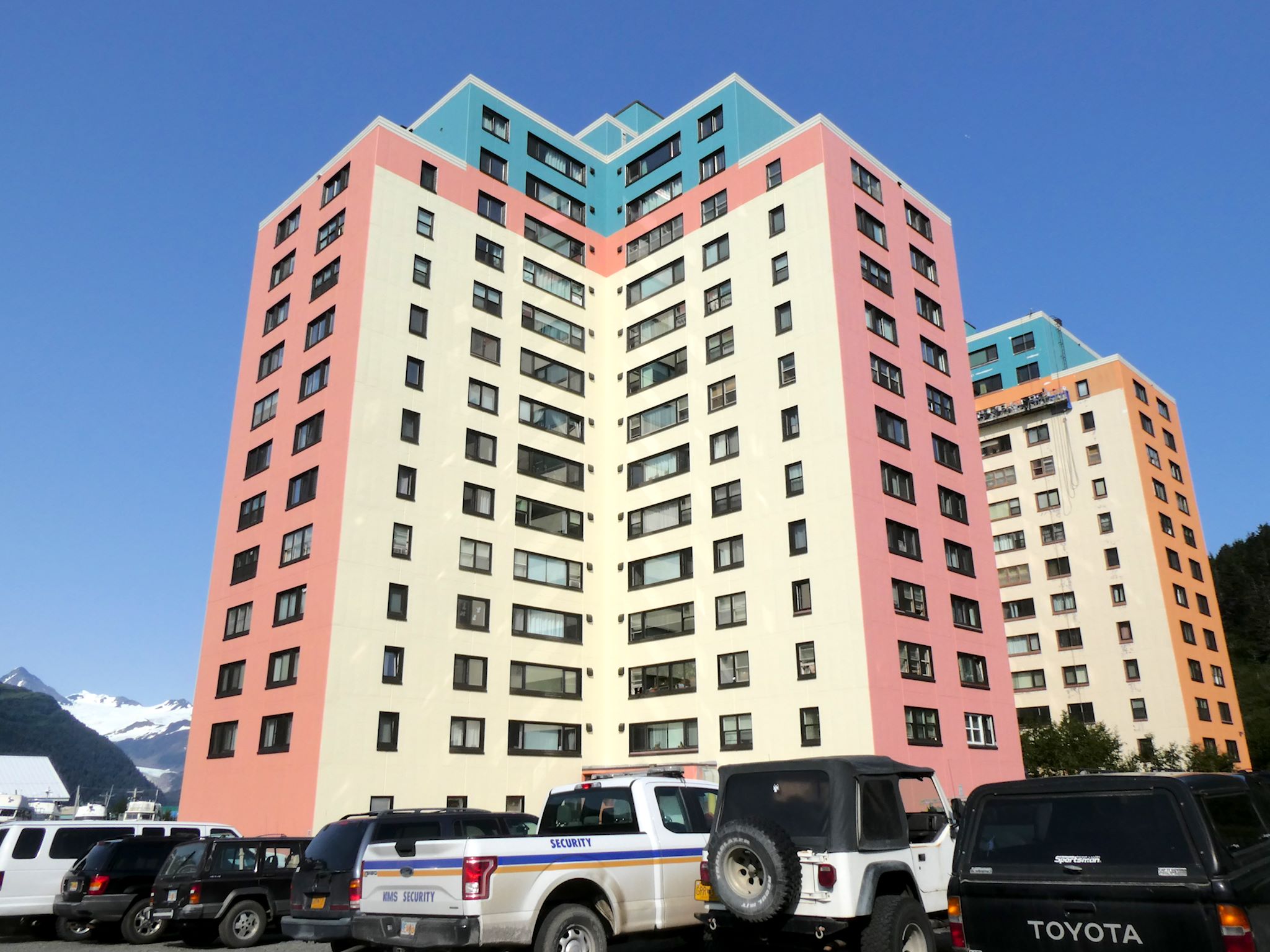
Whittier is reached through a single one-lane tunnel, and nearly all 270 residents live in one 14-story building that also contains the school, post office, grocery store, and church.

Whittier sits at the head of a fjord in Prince William Sound, ringed by 1,200-metre peaks and pinned against the water by a wall of rock. Roughly 270 people live there year-round, and the easiest way to describe Whittier is by what's missing: no through road, no suburbs, no second high-rise. There is essentially one building, Begich Towers, and it contains the town.
A US Army base that never quite left
Whittier was built during World War II as a secret deep-water port for the US Army. The harbour stays ice-free year-round and is shielded from observation by the Chugach Mountains. To reach it, engineers carved the 4-kilometre Anton Anderson Memorial Tunnel through Maynard Mountain in 1943. After the war, the Army built two large concrete towers to house personnel: Hodge Building (now Begich Towers, completed 1957) and the Buckner Building (completed 1953).
The military left in 1960. Buckner, once the largest building in Alaska, was abandoned and still stands derelict on the hillside, slowly losing its windows. Begich Towers was sold off to the city, converted to condominiums in the 1970s, and became home to most of Whittier's civilian population.
Life inside Begich Towers
Begich Towers is fourteen floors and roughly 196 units. Inside, the building functions like a vertical village. The basement and ground floor contain the post office, a small grocery, a Laundromat, a B&B, the police office, a clinic, and a small church. A heated underground tunnel runs from Begich Towers to the school across the street, so children never have to walk outside in winter, useful in a town that receives more than 5 metres of snowfall a year.
Residents say they bump into the same neighbours dozens of times a day, in elevators and the lobby. The town's mayor has historically lived in the building. So has the school principal, several teachers, and most of the local commercial fishermen.
The one-lane tunnel and the schedule
Until 2000, the Anton Anderson tunnel was rail-only. That year it was rebuilt as North America's longest combined road-and-rail tunnel: a single shared lane that alternates between cars headed east into Whittier, cars headed west toward Anchorage, and freight or passenger trains on the Alaska Railroad. The schedule is published online and posted at both portals. Miss your slot and you wait, up to an hour, for the next opening. The tunnel closes overnight; if you arrive in Whittier after the last departure, you spend the night.
Fun facts
- Local saying: "The weather here is shittier in Whittier." Average annual rainfall: 5,000 mm (almost 200 inches).
- The abandoned Buckner Building, still visible above town, was once nicknamed "the city under one roof." Begich just inherited the title.
- There is no resident dentist in Whittier. The dental chair is in a converted unit and rotated through visiting practitioners.
- The town's only land access is the tunnel; barge and ferry handle freight. Cruise ships call here in summer to disembark passengers headed for Anchorage by train.
Gallery
.jpg)

.jpg)
Sources
Other interesting places
View all →


Featured lists
View all lists →


Keep exploring
See Whittier on the map
Terralocate is a place encyclopedia covering thousands of towns worldwide. Open Whittier's page for coordinates, population, nearby places, and an interactive map — or jump into the rest of United States.
Compare cities, side by side
Choose any 2 cities →


Text on this page is original Terralocate editorial. Background facts compiled from the public sources listed above. Images via Wikimedia Commons under their respective licenses (typically CC BY-SA or public domain).