The volcano you can sail a ship straight into
Deception Island
A flooded volcanic caldera in the South Shetland Islands where ships enter through a narrow break in the crater wall into a sheltered harbor above still-active magma.

Deception Island, part of the South Shetland Islands off the Antarctic Peninsula, is one of the strangest landforms on the planet, an active volcano whose collapsed caldera has flooded with seawater, creating a natural harbor that ships can sail directly into through a narrow gap in the crater wall known as Neptune's Bellows. Shaped roughly like a horseshoe, the island's ring-shaped rim nearly encloses Port Foster, the flooded caldera at its center, offering one of the few sheltered anchorages in the notoriously stormy Southern Ocean. The volcano remains active, having erupted as recently as 1970, and geothermal heat still warms parts of the shoreline enough that steam rises from the black volcanic sand and swimmers can find pockets of surprisingly warm water amid the freezing Antarctic surroundings. Historically used as a whaling station in the early 20th century, the island today hosts scientific research stations and is a popular stop for Antarctic tourism cruises, drawn by the surreal experience of sailing into the heart of a live volcano at the bottom of the world.
Sailing Into a Volcano
The defining feature of Deception Island is Neptune's Bellows, a narrow entrance roughly 230 meters wide cutting through the volcanic rim, allowing ships to pass directly from the open ocean into Port Foster, the flooded caldera occupying the island's center. This makes Deception Island one of very few places in the world where vessels can sail into an active volcanic crater.
The passage is not without hazard, strong currents and a submerged rock known as Ravn Rock lurk near the entrance, and navigators must time their approach carefully with tidal conditions. Once inside, however, the caldera offers calm, sheltered water, a rare refuge amid the ferocious winds and waves typical of the Drake Passage and surrounding Southern Ocean.
The island's horseshoe shape formed following a massive volcanic collapse thousands of years ago, when the center of an earlier, larger volcano caved in and filled with seawater, leaving behind the ring-shaped remnant that exists today, a form geologists classify as a caldera.
A Volcano That Is Still Alive
Deception Island is not a dormant curiosity but an active volcano that has erupted multiple times within recorded history, including notable eruptions in 1967, 1969, and as recently as 1970. These eruptions caused significant damage to scientific stations located on the island, forcing evacuations and, in some cases, permanent abandonment of research facilities.
Geothermal activity remains evident across parts of the island today, with steam occasionally rising from fumaroles and warmed patches of black volcanic sand along certain beaches. In some areas, heat from below the surface warms shallow coastal water enough that visitors have been known to dig small pools in the sand and briefly bathe, an almost absurd juxtaposition given the freezing Antarctic air and glacier-covered surroundings just meters away.
Scientists continue to monitor the volcano closely, given its history of unpredictable activity, and its ongoing geothermal signature makes it a valuable site for research into volcanic and geological processes at high latitudes.
From Whaling Station to Scientific Outpost
In the early 20th century, Deception Island's sheltered harbor made it an attractive base for the whaling industry, and a Norwegian-Chilean whaling company established a station at Whalers Bay inside the caldera beginning in 1912. For nearly two decades, the site processed thousands of whales, leaving behind rusted boilers, storage tanks, and abandoned buildings that still stand today as haunting relics of the industry.
After whaling declined, several nations established scientific research stations on the island, including facilities operated by the United Kingdom, Argentina, Spain, and Chile at various points. Volcanic eruptions in the late 1960s severely damaged or destroyed several of these stations, and the British base was ultimately abandoned following the 1969 eruption, which triggered dangerous mudflows called lahars.
Today, Spain and Argentina continue operating seasonal research stations on the island, studying everything from volcanic activity to the surrounding marine ecosystem, while the abandoned whaling infrastructure has become a protected historic site managed under Antarctic Treaty guidelines.
A Surreal Stop for Antarctic Tourism
Deception Island has become one of the most popular destinations for Antarctic Peninsula cruise itineraries, offering tourists the rare chance to sail into an active volcanic caldera and walk among the rusting remnants of a century-old whaling station. Ships that manage safe passage through Neptune's Bellows anchor within Port Foster, allowing passengers to go ashore at sites like Whalers Bay.
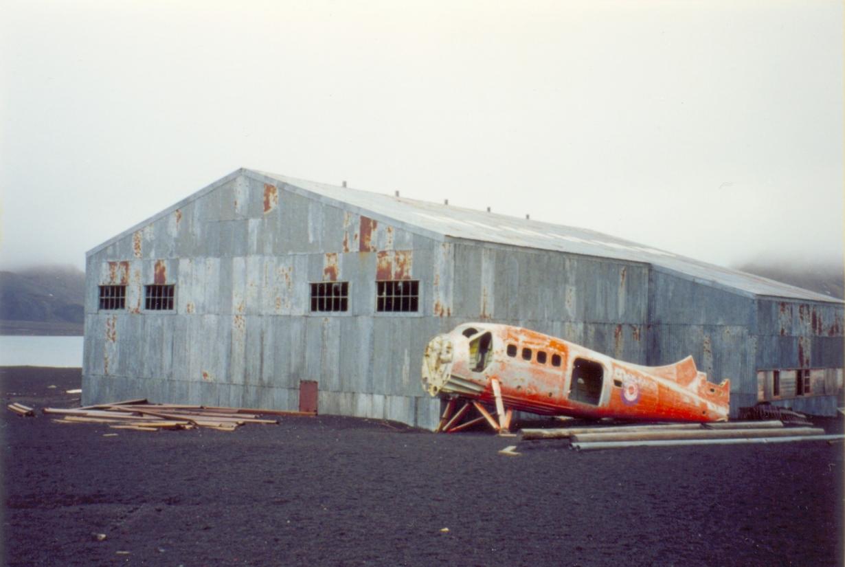
Visitors can view abandoned whale oil tanks, collapsed buildings, and even a small aircraft hangar built for early Antarctic exploration flights, all set against a stark backdrop of black volcanic sand, steaming vents, and glacier-capped crater walls. Some tour operators offer polar plunge experiences in the geothermally warmed shallow waters near the shore, an experience unique to this particular island.
Expedition guides emphasize the island's dual identity as both a site of dramatic natural history and human industrial history, a place where volcanic forces, marine wildlife, and the legacy of the whaling era intersect within the confines of a single collapsed volcano, making it one of the most visually and scientifically compelling stops in all of Antarctica.
Fun facts
- Ships enter the flooded volcanic caldera through a narrow gap called Neptune's Bellows, about 230 meters wide.
- Deception Island has erupted multiple times in recorded history, most recently in 1970.
- Geothermal heat still warms parts of the beach, letting visitors dig warm bathing pools in the sand.
- A whaling station operated in Whalers Bay from 1912, leaving rusted tanks and buildings still visible today.
- Volcanic eruptions and mudflows forced the abandonment of the British research station on the island in 1969.
Gallery


Sources
Other interesting places
View all →


Featured lists
View all lists →


Compare cities, side by side
Choose any 2 cities →


Text on this page is original Terralocate editorial. Background facts compiled from the public sources listed above. Images via Wikimedia Commons under their respective licenses (typically CC BY-SA or public domain).